本文已被:浏览 2052次 下载 3898次
投稿时间:2017-09-19 修订日期:2018-12-27
投稿时间:2017-09-19 修订日期:2018-12-27
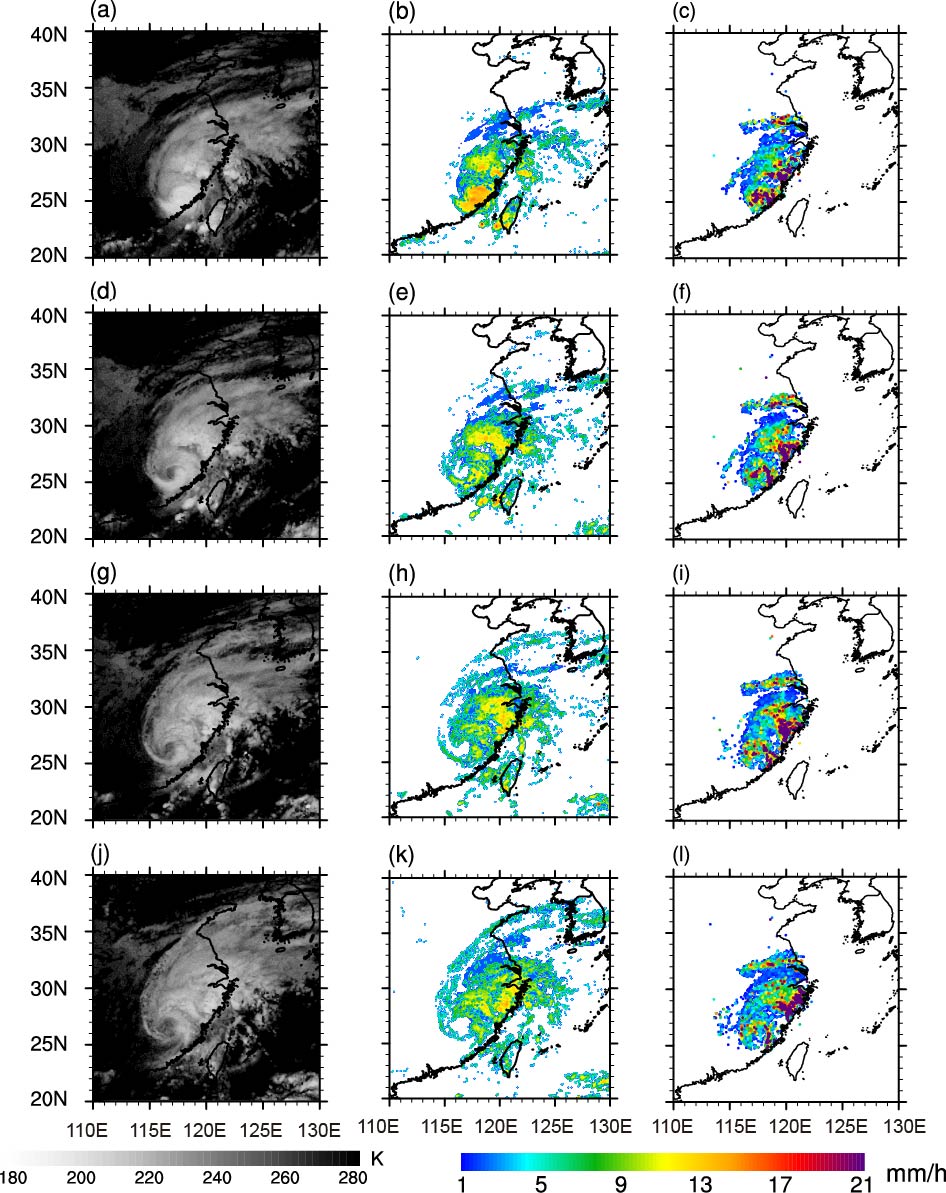
中文摘要: 为探究高时空分辨率卫星资料在我国登陆台风降水预报中的作用,本文针对2016年14号超强台风莫兰蒂,采用Himawari 8亮温资料通过定量降水估计(quantitative precipitation estimation,QPE)方法估算降水强度,并利用国家气象信息中心全国综合气象信息共享系统(China Integrated Meteorological Information Sharing System,CIMISS)提供的台站降水资料进行质量评估。结果表明:(1)卫星估算与地面实测的降水落区有较好的对应关系,但是卫星高估了弱降水,而低估了强降水(尤其在高海拔地区);(2)卫星估算与地面实测的降水强度并非同位相变化,而是实测降水滞后于卫星估算的降水,该滞后时间在台风登陆后的移动区较长(约2~2.5 h);(3)整体而言,卫星估算的某时刻降水强度与未来一段时间内(约2~2.5 h)该地区的实际总降水量有很强相关性,说明Himawari 8卫星估算的降水可在台风降水的预警预报中提供指示作用。
Abstract:In order to explore applications of satellite data with high resolution to the prediction of typhoon precipitation, a landfall typhoon case (Super Typhoon Meranti) was studied by using Himawari 8 (H8) satellite data. The precipitation intensity was estimated first by using an improved QPE (quantitative precipitation estimation) method and then evaluated by observation dataset from CIMISS (China Integrated Meteorological Information Sharing System). The results are as follows. (1) The precipitation estimated from H8 satellite has a good correspondence with the ground observations in terms of rainfall area, but the satellite overestimates weak precipitation and underestimates heavy rainfall, especially at high altitudes, which is due to lack of consideration of terrains’ effect on promotion of precipitation in the QPE algorithm. (2) The time series of precipitation intensity from estimation and observation do not vary in same phase, and the observed precipitation lags behind the estimation. (3) Generally, the precipitation intensity estimated by the H8 satellite is positively correlated with the total precipitation later observed over a period (about 2-2.5 h). Besides, the correlation is also large between the total precipitation over a period (about 2-2.5 h) estimated by the satellite and the precipitation intensity measured on the ground later. This indicates that precipitation estimated by the H8 satellite could play an indicative role in the early warning of typhoon precipitation.
文章编号: 中图分类号: 文献标志码:
基金项目:上海市气象局科技开发项目(QM201711)、上海市自然科学基金项目(18ZR1434100)、上海市定向征集项目(17DZ1205300)、华东区域气象科技协同创新基金合作项目(QYHZ201611)和国家自然科学基金项目(41405046)共同资助
引用文本:
燕亚菲,谈建国,崔林丽,岳彩军,郭巍,刘冬韡,2019.利用葵花8号(Himawari-8)高时空分辨率的红外亮温资料估计台风莫兰蒂的短时强降水及其演变[J].气象,45(3):318-329.
YAN Yafei,TAN Jianguo,CUI Linli,YUE Caijun,GUO Wei,LIU Dongwei,2019.Estimating the Short Time Severe Precipitation of Typhoon Meranti and Its Evolution by Using the Infrared Brightness Temperature Data from Himawari 8 Satellite with High Spatio Temporal Resolution[J].Meteor Mon,45(3):318-329.


