本文已被:浏览 1197次 下载 6334次
投稿时间:2018-12-22 修订日期:2020-04-04
投稿时间:2018-12-22 修订日期:2020-04-04
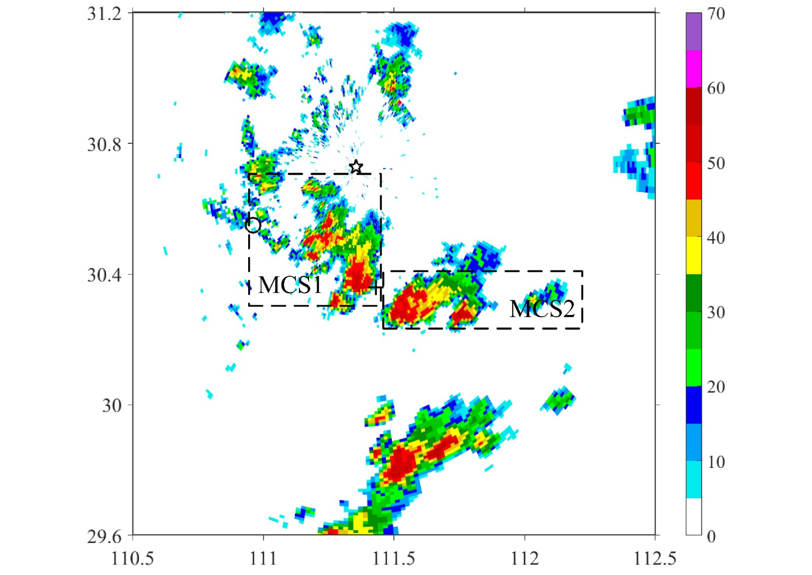
中文摘要: 利用多普勒天气雷达和区域自动气象站资料以及常规观测资料,分析了2016—2017年宜昌极端短时强降水的环境条件和中尺度对流系统(MCS)的演变与活动特征。结果表明,极端短时强降水发生的形势背景共有三种:斜压锋生、准正压和低层暖平流强迫。在斜压锋生环境中,冷锋南下在宜昌中西部速度变缓,与暖倒槽中暖湿气流多次合并形成锋生,其造成的强烈抬升使MCS中单体质心较高,强回波厚达5~6 km,强的垂直切变导致单体出现悬垂结构,这些环境条件使气流合并时瞬时雨强较大;在气流合并、地形阻挡时对流持续时间较长,造成间歇性、分散性极端短时强降水。准正压Ⅰ型极端短时强降水发生在副热带高压边缘,地面鞍型场中南风气流发展,在地形作用下形成的辐合中心触发并增强对流单体,低质心、塔状、厚度高达7 km的强回波造成的瞬时雨强极大,引导气流较弱及下游山前减弱单体的后向传播效应导致山前的河谷地区对流再次加强,造成时间较短、范围极小而雨强极大的极端短时强降水;准正压Ⅱ型极端短时强降水发生在东风波西移过程中,暖湿的东风气流与边界层偏北气流合并时,导致超低质心的深厚塔状强降水回波,山体东侧过渡带地形使偏北风、偏东风多次合并,因而在过渡带地区造成雨强相对较小而范围较大、持续几个时次的极端短时强降水。在暖平流强迫环境中,西南急流加强时地面发展出辐合线,在辐合线上有向下游倾斜的深厚强回波单体沿着辐合线间隔排列,切变线、辐合线和雨带走向一致,使对流线上单体出现“列车效应”,对流单体在对流线的上游新生、加强,向下游移动,在对流线上连续几个时次出现间隔分布的线状极端短时强降水。
中文关键词: 极端短时强降水,准静止,后向传播,列车效应
Abstract:Based on Doppler radar data, automatic weather station data and conventional observation data, the environmental conditions and mesoscale convective system (MCS) in Yichang from 2016 to 2017 were analyzed. The results showed that there are three synoptic situation configurations of extreme flash rain (EFR): baroclinic frontogenesis category, quasi-barotropic category and low-level warm advection forcing category. In the baroclinic frontogenesis environment, the cold front is slower in the central and west of Yichang. The heavy updraft caused by the front, which is stronger, combined with the warm and humid airflow makes MCS high and thick. The strong vertical shear causes hanging structure of the cell. The instantaneous rainfall intensity is stronger and the duration of convection is longer when the airflows are converged and blocked by the terrain, resulting in intermittent and dispersive EFR. The quasi-barotropic type Ⅰ occurs at the inner edge of the subtropical high. The center of convergence formed by the topography with developing of the southerly in the saddle field triggers and strengthens the convective cell, causing heavy instantaneous rain intensity. Extremely, the weak steering flow and the backward propagation effect of the weakening cell in the piedmont area of the downwind side cause the convection to be streng-thened again in the valley area in front of the mountain, resulting in EFR with short time, very small range and heavy rain intensity. The quasi-barotropic type Ⅱ occurs at the convergence of the warm moist easterly and northerly flow of the boundary layer while the easterly wave moves to west, resulting in heavy precipitation tower deep echoes with ultra-low center of mass. The topographical transition zone on the east side of the mountain merges the northerly wind and the easterly wind several times, causing the EFR with relatively small intensity, larger area and lasting several times. In the warm advection forcing environment, a convergence line is formed with the strengthening of southwestern jet. The deep and strong echoes inclined downstream are arranged along the convergence line. The shear line and convergence line are in accord with the trend of rain band and the “train-effect” appears on the convection line, causing the cell to be regenerated and strengthened, moving downstream in the upstream of the convection line. So the line EFR with discontinuity distribution appears some times in a row on the convection line.
文章编号: 中图分类号: 文献标志码:
基金项目:中国气象局预报员专项(CMAYBY2017-047)资助
| 作者 | 单位 |
| 范元月 | 湖北省宜昌市气象台,宜昌 443000 |
| 罗剑琴 | 湖北省宜昌市气象台,宜昌 443000 |
| 张家国 | 武汉中心气象台,武汉 430074 |
| 叶丹 | 湖北省宜昌市气象台,宜昌 443000 |
| 陈亮 | 湖北省宜昌市气象台,宜昌 443000 |
引用文本:
范元月,罗剑琴,张家国,叶丹,陈亮,2020.宜昌极端短时强降水中尺度对流系统特征分析[J].气象,46(6):776-791.
FAN Yuanyue,LUO Jianqin,ZHANG Jiaguo,YE Dan,CHEN Liang,2020.Characteristics Analysis of Mesoscale Convective System Causing the Extreme Flash Rain in Yichang[J].Meteor Mon,46(6):776-791.
范元月,罗剑琴,张家国,叶丹,陈亮,2020.宜昌极端短时强降水中尺度对流系统特征分析[J].气象,46(6):776-791.
FAN Yuanyue,LUO Jianqin,ZHANG Jiaguo,YE Dan,CHEN Liang,2020.Characteristics Analysis of Mesoscale Convective System Causing the Extreme Flash Rain in Yichang[J].Meteor Mon,46(6):776-791.


